


Rice Seedling Dataset 水稻秧苗辨識資料集
Datasets for rice seedling detection model training, validating, testing.
Related Publications
-
A UAV Open Dataset of Rice Paddies for Deep Learning Practice
The data descriptor was published on Remote Sensing, MDPI. (open access) -
Rice Seedling Detection in UAV Images Using Transfer Learning and Machine Learning
An application of rice seedling detection using transfer learning was published on Remote Sensing, MDPI. (open access)
MDPI and ACS Style
- Yang, M. D.; Tseng, H. H.; Hsu, Y. C.; Yang, C. Y.; Lai, M. H.; Wu, D. H. A UAV Open Dataset of Rice Paddies for Deep Learning Practice. Remote Sens. 2021, 13, 1358. doi:10.3390/rs13071358
- Tseng, H. H.; Yang, M. D.; Saminathan, R.; Hsu, Y. C.; Yang, C. Y.; Wu, D. H. Rice Seedling Detection in UAV Images Using Transfer Learning and Machine Learning. Remote Sens. 2022, 14, 2837. doi:10.3390/rs14122837
Contents
1. Basic Data Information
2018 Orthomosaic image
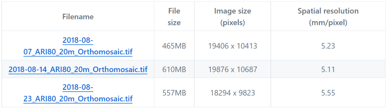
These three links are the orthomosaic image of paddy No.80, TARI, which were in TWD97 / TM2 zone 121 (EPSG:3826) projection. The images were acquired in three consecutive growing stages in 2018.
Expansion Orthomosaic image (2019-2020)
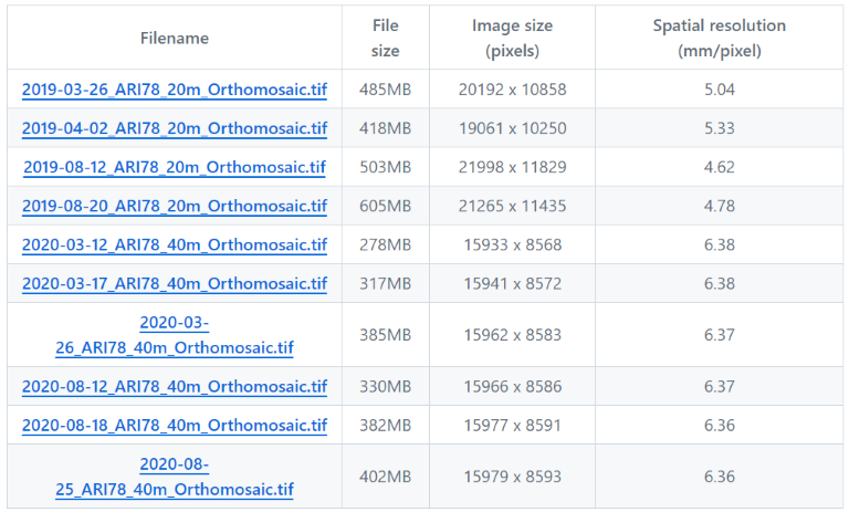
These 10 links are the orthomosaic image of paddy No.78, TARI, which were in TWD97 / TM2 zone 121 (EPSG:3826) projection. The images were acquired in 2019 and 2020.
Dataset of Rice Seedling Classification (Train-Val)
RiceSeedlingClassification.tgz (uncompressed size 426MB)
This file includes two folders: riceseedling and arableland. Train-val and test datasets are all included.
Dataset of Rice Seedling Detection (Train-Val)
RiceSeedlingDetection.tgz (uncompressed size 19.1MB)
This is a PASCAL VOC format object-detection dataset, which includes two folders: JPEGImaegs and Annotations.
Dataset of Detection Demonstration (Test)
RiceSeedlingDemo.tgz (uncompressed size 48.5MB)
This file contains 8 detection demo images and the corresponging PASCAL VOC xml format annotations.
An overview of the region of different datasets
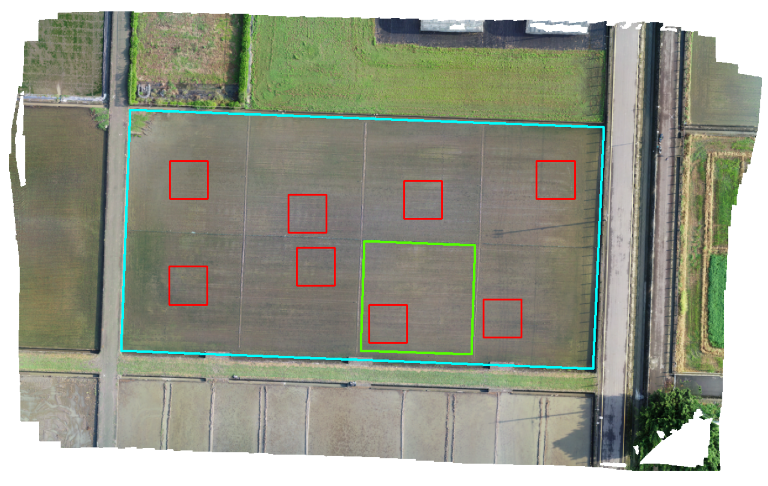
An overview of the field no. 80 (cyan bounding area) in TARI, Taichung. Image acquired on August 7, 2018. The green bounding area represents the area for training-validation dataset, and the red bounding area represents the subsets for object detection demonstration dataset.
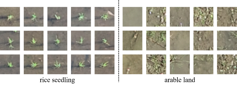
2. Dataset of Rice Seedling Classification
This dataset contains two classes:
rice seedlingarable land
An overview of image dataset
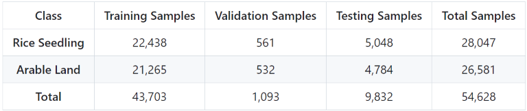
The number of images used for training, validation, and testing in the rice seedling dataset
3. Dataset of Rice Seedling Detection
This dataset is used for object-detection model training and validation.
- PASCAL VOC xml format annotation
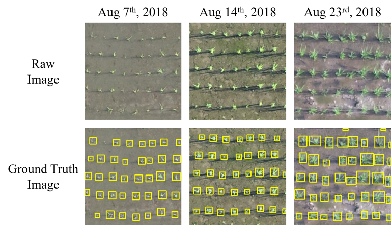
- 3 consecutive mission: Aug 7th, Aug 14th and Aug 23rd
- 8 subsets
- 25 samples/subset
- 600 samples total
Examples of three growth stages of the rice seedling detection dataset
4. Detection Demo Dataset
This dataset is used for patch-based object-detection scenario.
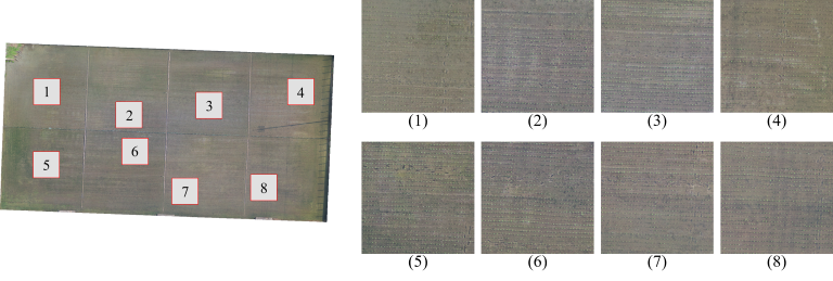
- 8 subsets
- 8m x 8m region
- 1527 x 1527 pixels
- PASCAL VOC xml format annotation
An overview of 8 detection demo images
データとリソース
-
RiceSeedlingClassification.tgzTAR
This file includes two folders: riceseedling and arableland. Train-val and...
-
RiceSeedlingDetection.tgztgz
Dataset for rice seedling object detection model training, validation....
-
RiceSeedlingDemo.tgztgz
This tgz file contains 8 detection demo images and the corresponging PASCAL...
-
2018-08-07_ARI80_20m_Orthomosaic.tifTIFF
Orthomosaic image of paddy No.80, TARI. (in TWD97 / TM2 zone 121 (EPSG:3826)...
-
2018-08-14_ARI80_20m_Orthomosaic.tifTIFF
Orthomosaic image of paddy No.80, TARI. (in TWD97 / TM2 zone 121 (EPSG:3826)...
-
2018-08-23_ARI80_20m_Orthomosaic.tifTIFF
Orthomosaic image of paddy No.80, TARI. (in TWD97 / TM2 zone 121 (EPSG:3826)...
-
2019-03-26_ARI78_20m_Orthomosaic.tifTIFF
Orthomosaic image of paddy No.78, TARI. (in TWD97 / TM2 zone 121 (EPSG:3826)...
-
2019-04-02_ARI78_20m_Orthomosaic.tifTIFF
Orthomosaic image of paddy No.78, TARI. (in TWD97 / TM2 zone 121 (EPSG:3826)...
-
2019-08-12_ARI78_20m_Orthomosaic.tifTIFF
Orthomosaic image of paddy No.78, TARI. (in TWD97 / TM2 zone 121 (EPSG:3826)...
-
2019-08-20_ARI78_20m_Orthomosaic.tifTIFF
Orthomosaic image of paddy No.78, TARI. (in TWD97 / TM2 zone 121 (EPSG:3826)...
-
2020-03-12_ARI78_40m_Orthomosaic.tifTIFF
Orthomosaic image of paddy No.78, TARI. (in TWD97 / TM2 zone 121 (EPSG:3826)...
-
2020-03-17_ARI78_40m_Orthomosaic.tifTIFF
Orthomosaic image of paddy No.78, TARI. (in TWD97 / TM2 zone 121 (EPSG:3826)...
-
2020-03-26_ARI78_40m_Orthomosaic.tifTIFF
Orthomosaic image of paddy No.78, TARI. (in TWD97 / TM2 zone 121 (EPSG:3826)...
-
2020-08-12_ARI78_40m_Orthomosaic.tifTIFF
Orthomosaic image of paddy No.78, TARI. (in TWD97 / TM2 zone 121 (EPSG:3826)...
-
2020-08-18_ARI78_40m_Orthomosaic.tifTIFF
Orthomosaic image of paddy No.78, TARI. (in TWD97 / TM2 zone 121 (EPSG:3826)...
-
2020-08-25_ARI78_40m_Orthomosaic.tifTIFF
Orthomosaic image of paddy No.78, TARI. (in TWD97 / TM2 zone 121 (EPSG:3826)...
-
名無しのリソース
追加情報
| フィールド | 値 |
|---|---|
| 作成者 | 曾信鴻 |
| メンテナー | 曾信鴻 |
| 最終更新 | 9月 3, 2025, 11:28 (CST) |
| 作成日 | 9月 3, 2025, 11:28 (CST) |
| access_controller_url | https://aidata.nchu.edu.tw/smarter/dataset/smarter_07_5d4088_0_rice_20240318_objc_detect |
| access_type | 1 |
| harvest_object_id | aa7ad3ae-8ec1-479f-87f6-441d1765cdfb |
| harvest_source_id | 7c2f9114-b30c-44a2-a367-fa66300f3b67 |
| harvest_source_title | 中興大學大數據中心(AI-Data) |
推薦資料集: